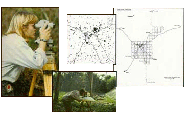
 Extensive mapping has been undertaken at Caracol. Approximately 17 square kilometers of the site have been transit-mapped, or approximately 10% of the estimated 177 square kilometers that once made up the city of Caracol. Whereas Satterthwaite’s early map of the site only showed 78 structures, some 5,000 structures (out of an estimated 36,000) have now been recorded at Caracol. Survey and reconnaissance have also revealed an extensive radiating solar causeway system that served to integrate the site. Caracol’s causeway termini are regularly spaced throughout its urban landscape, much like modern malls, and probably functioned as market and administrative areas in antiquity.